Web-based Environmental Monitoring and Early Warning System as a Part of the Wendlingen-Ulm High-Speed Railway Project

")

Commissioned by
Bernd Gebauer Ingenieur GmbH
Project period
2012 – ongoing
Location
Ulm-Wendlingen, Germany
Project description
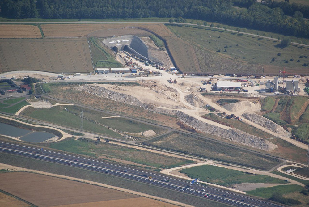
The construction of the Albabstieg railway tunnel is a parallel project to the Stuttgart21 project and is part of the Wendlingen-Ulm high-speed railway, a section of the Stuttgart- Augsburg project, an extensive railway and urban development project in Germany.
The Swabian Jura (Schwäbische Alb) is a low mountain range located in southern Germany in the state of Baden-Württemberg. It consists mostly of different layers of limestone formed in the Jurassic period covered with Tertiary sediments (Henningsen & Katzung 2006). Due to the complex groundwater situation in the Swabian Jura region, a spatially and temporally small-meshed water level monitoring during railway tunnel construction was required. To comply with these requirements ribeka was assigned to develop a web based information, monitoring and early warning system.
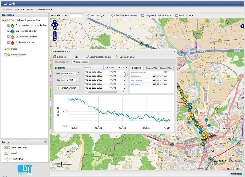
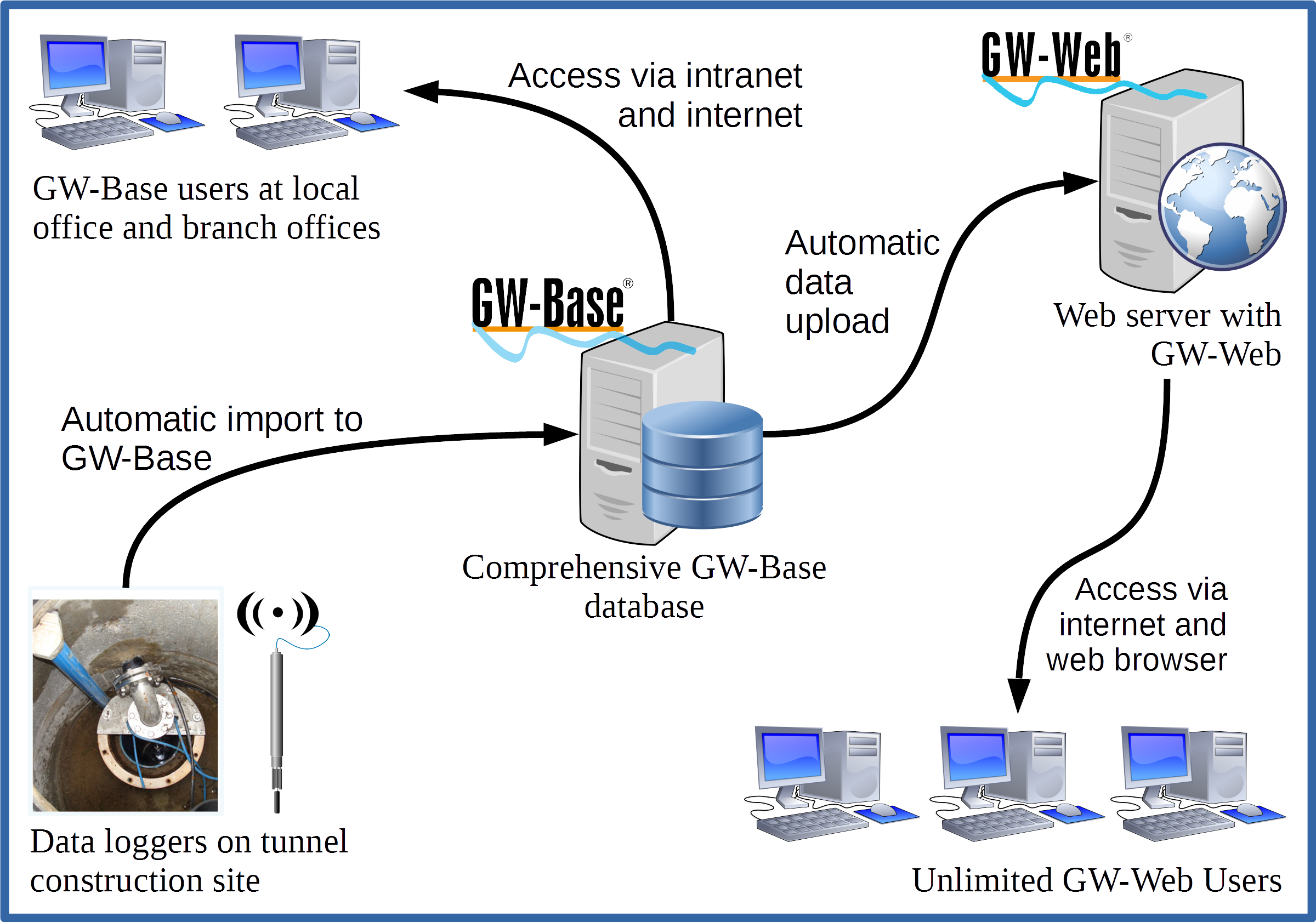 In the beginning of 2012, automatic SEBA GPRS/GSM water level loggers were installed and set into service in all designated monitoring station along the Albabstieg railway tunnel track. Since then, the logged water levels are automatically imported to ribekas water monitoring and management system GW-Base as well as to a newly developed web application. The web application is based on ribekas web solution GW-Web which was extended with necessary project specific functionalities. Next to basic functionalities like map display and basic station information, GW-Web offers time series diagrams of water levels, water analysis parameters and climate data, display of bore log and station construction data as well as a sophisticated document and user management. Among the special and customized functionalities are multiple geological cross sections which feature a real-time water level display and the display of the tunnel face advance. A comprehensive automatic warning system concerning water level and analysis parameter thresholds ensures the possibility of timely reaction measures in case of any incidence.
In consequence of the large scale groundwater drawdown required for the tunnel construction and the consequent groundwater reinfiltration tasks to recharge the natural aquifer a comprehensive water quality monitoring and a consistent reporting to the responsible environmental authority and all groundwater stakeholders is required. All Water quality measurements as well as laboratory water sample analysis are managed in GW-Base and automatically uploaded to the web tool. In addition, periodic report documents and surveys are published to the internet and are made available to authorized stakeholders and charged authorities.
The complete system is installed on the customer’s server infrastructure at their headquarters in Munich and facilitating remote access from all involved branch offices as well as from the tunnel construction headquarters in Ulm.
Download
Other projects
Groundwater Managementsystem in Yuncheng, P.R. China
Water supplier RWW-RWE